In 1994 I went on a 25 day cycle tour of the Nordic Countries (Norden) and fell in love with the place. So I wanted to return to see some more of the area. In the meantime I had made 2 winter ski trips in Norway. I also tried to learn a bit of the languages (mostly Norwegian Bokmål).
About languages. It seems that most people between age 15 and 50 in Scandinavia speak excellent English so there usually is no problem. However it is nice to be able to read signs and maybe even newspapers. The 4 official written languages of Danish, Swedish, Bokmål and Nynorsk are quite similar. (Finnish is completely different). Understanding spoken languages is much harder since there are dozens of dialects.
A very useful book for touring Norway is SYKKEL FERIE I NORGE (Cycling Vacations In Norway), if one can read Norwegian Bokmål. It has 29 tours of Norway and includes geographic and historic facts about the areas.
I used the Cappelen maps of south Norway - scale 325000. It is good enough except near towns or near a major highway, where there isn't room of the map to show parallel roads.
Most places in Norden are very bicycle-friendly. Denmark is one of the most bicycle oriented countries in the world with more bicycles than cars. In Norway postmen deliver mail by bicycle in the middle of winter. One bicycle-friendly aspect that I didn't fully appreciate until I returned to Canada was the action of the dogs. Dogs never chase cyclists and there are many dogs in Norway. Here are some of the road types in Norway.
RIKSVEG (RV)- main national, numbered highways, usually the ones with small numbers have heavier traffic. Some are designated as European Highways, with E-numbers. Some sections are motorways and no cycling is allowed, but often those sections will have a paved bike path or the old road alongside. Cycling isn't allowed in long tunnels, and it isn't very pleasant anyways, so I avoided them. Sometimes there are old roads bypassing the tunnels.
FYLKEVEG (FV)- county roads. Usually narrow with light traffic but some sheep. Sometimes unpaved (grusveg) but usually good condition and very pleasant cycling.
BOMVEG- privately maintained gated roads. Some are open to motor traffic for a toll, others are closed to all except local landowners. Cyclists and walkers can freely use them. Usually good condition. Very pleasant semi-wilderness cycling with very little motor traffic but lots of sheep. Some are marked as cycling routes like in Oslo's Nordmarka.
GANG OG SYKKELVEG (G/SV). Paved walking and cycle paths. Sometimes there is a line separating walking and cycling lanes. In Norway and Sweden they are fairly common, especially in or near towns, in Denmark they cover most of the country.
My original plan was to spend the first week riding in flat Denmark, ride through Sweden and then tackle the big mountains of Norway at the end of the trip. Maybe I would even have time for a short look at Finland too.
For money I used bank machines- MINIBANK, AUTOBANK etc., which are quite common. Some take VISA cards and some take PLUS system cards. The worst place to change money is at the money exchange offices in airports- they charge a big surcharge.
In Norway and Sweden I planned to camp most of the time and then stay at a hostel (vandrerhjem) every 3rd night. In Denmark I would stay in hostels every night. In Norway the overnight fee usually included a buffet (smörgåsbord) breakfast.
I flew overnight from Halifax to Oslo with a plane change in Iceland. I took my chances and just put the bike in a plastic bag supplied at the airport. On overseas flights there is no extra charge for a bicycle. I was allowed one other piece of baggage- my panniers and camping equipment were tied up and put in a plastic bag.
MY STEED: Custom made touring 531DB bike from Tamarack Cycles; Randonneur handle bars with Suntour Bar-cons; Avocet Cross tires 700x35 on Mavic rims (36 spokes); Sachs New Success Group; front gears 50-40-28, rear 13-30(7 sp); Blackburn rear rack and front low riders; Esge fenders; Brooks B17 saddle. Carrying large rear panniers, small front panniers, handlebar bag, 1 person tent , sleeping bag and thermarest, GAZ stove. I had a Vistalight rear light and a Petzl micro headlamp.
Perhaps an hour later I was out riding. There is a paved bike path along the highway. I spent a little time looking for the ferry dock for the boat to Nesodden. I remembered it as being somewhere near the airport but I didn't have my good city map of Oslo. The boat only runs during rush hours so I headed toward downtown.
My wheel didn't stay true so I stopped to retrue it again. I considered going to a bike shop and buying a new rim. But how long would it take a bike shop to build a wheel? Would they even have a 36 spoke rim? they seem to be rare now. How long would it take me to rebuild a wheel? At home, with a truing stand, it takes me 2 or 3 hours. My damaged wheel did last for the next 5 weeks and 4000 km. When I got home I got a new FREE rim from the bike shop, under Mavics warranty.
I was still planning to ride south this afternoon, possibly as far as Moss. Then it started to rain. I stopped in a little shelter and took time to think. I only had about 2 hours sleep. I have changed time zones by 5 hours. I may have a mortally damaged wheel. I haven't bought any groceries yet. It is raining. So it seemed like a good idea not to go anywhere today but stay overnight and get a good night's sleep.
My first thought was to go to Haraldsheim Vandrerhjem (youth hostel) but that was way across the city. I checked the hostel book and there was a summer hostel at Holtekilen, not far away. The book gave directions from Stabekk station so I found my way up there, and eventually to the hostel around 1600. It was almost full. There was a bus full of students from France but I got a bed.
I noticed a lots of cyclists and very few cars on the street Michelets Vei. I decided to check it out. There was a gate across the street with an opening for pedestrians and cycles. I followed the street and it lead to, surprise, Fornebu airport- only a 5 minute ride! So I took another look for the ferry dock. It is actually at the Sjöfly Havn Kro (Seaplane Haven Restaurant) directly across from the airport terminal building. Another nice thing about Fornebu is that it is only a 5 minute walk from the terminal building to a beach - not a real sandy beach, but I did see some kids swimming there later. The quick way from Fornebu to Holtekilen and to the west is to follow the bicycle route signs going to Sandvika.
On my way back I found a grocery store and got enough food for supper and lunch. My wheel seemed to be holding up now. Then I had supper and got a good night's sleep. It's so nice to hear the melodious sound of Norwegian again!
I found out that I could catch the ferry to Nesodden at either Lysaker or Fornebu. I headed for Lysaker and got on a boat at 0840. It is a fast catamaran and only took 15 minutes. This is actually a "bus" route on the Oslo regional transit system. As on all city busses there is a charge for the bicycle (half adult fare). It looked like many people keep 2 bicycles, one at each end of the ferry. In the morning all the passengers are coming to Oslo so I was the only person on the boat. Another larger but slower boat came into Nesoddtangen from Aker Brygg in downtown Oslo.
The road up from the landing is hilly but nice. It starts off on bike paths, then on quiet roads. The ferries don't carry cars and it is a 50 km drive around to this point so traffic is very light. It is a quiet, residential area, cleverly disguised as a Norwegian woods. It was a beautiful sunny morning. There were lots of lilac bushes along the road and lots of birds singing. What a morning! (background music: Peer Gynt's Morning by Grieg) At the top of the first climb there is a good view back over the fjord to Oslo, Holmenkollen ski-jump can be seen.
There are bicycle route signs to Moss. I was on Rv 157 for a while then turned off on some side roads. It was a mixture of forest and rolling farm lands. I bypassed Dröbak and the nearby fortress of Oscarborg, where in 1940 the ancient guns were used to sink the Blucher, the flagship of the invading nazi forces.
Then I was in more open rolling farmlands. I turned towards Vestby. I think I missed a corner, because I had to cross E6 twice. I had lunch by the fjord in the nice town of Son, home of a lot of artists. The streets are narrow - "kosilig" (cosy) as the bike book calls them and seemed to have more bikes than cars.
Then I was on to Moss thought the flatter farmfields of Östfold. I found a sports store and bought a CAMPING GAZ cartridge for my stove. These are quite available in Norden but PRIMUS is even more common. Unfortunately, I forgot to buy matches or a lighter!
I had a second lunch while waiting for the ferry to Horten which left at 1500. It was about a 30 min crossing.
In Horten I followed a bike path which seemed to end before I got to Borre. The book recommended Strandvegen, but warned that it might be muddy. It is a dirt path that is a little rough in places but goes through some beautiful woods right along the fjord's edge. It comes out of the woods in Aasgardsstrand, another artists' town with cosy streets that were completely empty.
Then it was an easy ride on paved bike paths to the old town of Tönsberg. It claims to be the oldest town in all of Norden. There is a reference in Snorri's sagas that the town was here before a famous battle in 872. But Snorri wrote his sagas in Iceland several hundred years later, so archaeologists have disputed the actual date.
I got to the youth hostel about 1800. I went down the pool a few blocks away but it was closed for maintenance. I took a walk up Slottberg behind the hostel. There is the ruins of a 1200 era castle and a tower erected for the towns 1000 anniversary. There is also a restaurant in the form of seter building, the mountain farm huts with a grass roof.
This was just a fabulous day with great scenery of all sorts: forests, fields hills and sea. It was hillier that I expected but I felt much stronger on the hills so I decided to postpone my trip to Denmark. The weather forecast called for several more days of sunny weather. I felt ready for some hills. So I decided to take a swing through Telemark region. The book described some interesting rides in the same area.
I had a map and route description of TELEMARK TOURS, a 2 day 380 km randonneur (motionlopp) event. It happened the week before. It goes from Skien to Rjukan and back. I decided to do most of the route in 4 days.
I saw a Norwegian cycling magazine, PÅ SYKKEL, in the hostel. There was a note that this would be a record early opening of Rallarvegen, the old railroad construction road across the mountains. Normally it isn't passable until late July, but people already cycling on it. I am planning to ride it in mid-July.
There were cycle paths out of town and I rode one for about 10 km to Sen where I crossed E18 and then went on Rv 312. This was rather nice road through rolling farmland, although there was moderate traffic - I'm already spoiled by some of the bike paths! At Andebu I turned off on Rv 307 which was another rolling road. This was probably not the optimum route towards Skien.
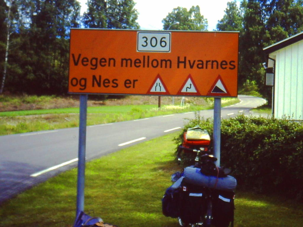
At Nes there is a sign saying that Rv 306 to Hvarnes is narrow, twisty, and steep. I must get used to this! This is Norway, after all! The road is mostly through woods with light traffic. There are a few switchbacks coming down to the next dale at Hvarnes. I followed the east bank of Lågen for a while before I found a bridge across to the other side where Rv 40 has fairly heavy traffic.
I stopped for lunch by Styrvoll kirke. Back on Rv 40 there was a construction area and fresh sticky tar. I got off on a section of the old road to the junction of Rv 32. There's more hills with moderate traffic and I pass into Telemark Fylke. I saw a guy on roller skis, double poling uphill. This is Norway, after all!
Then I go down another dale to Siljan, where there is a good paved bike path. Then it's up another set of hills. I had a second lunch at a lake where some kids were swimming but I thought the water was a bit chilly yet. Little did I know that the weather would never be this warm again!
About 5 km from Skien the bike path starts again. Skien is the home of Norways great author Ibsen and also of Monica Valvik, world champion female cyclist. However, I didn't go downtown, at Sem I turned off on a side road. The map showed Ibsens museum around here but I didn't see it.
After going through some rolling farmland to Aas I headed up a dale along Böelva into the woods. The road crosses a railroad track and the river several times . At one bridge were several people swimming. I found a nice spot along the river to stop for supper and maybe a swim. I was getting everything out then I discovered I had no matches or lighter. I decided to continue on the slight chance that there might still be a store open in the village of Nordagutu. The road goes further into the woods past Valebö It is narrow and is gravel for about 1 km. I pass many nice camping spots beside babbling becks, but I want to continue. The sun won't set until after 2300 and it will never get completely dark at this time of year.
When I got to Nordagutu about 2000, the store was closed. So I had a cold meal. Now I started looking for a nice spot to camp. No babbling becks here. I camped in a clearing about 10 km south of Notodden.
I finally got away around 10 and headed up Tinndalen along a nice quiet Fv. The dale narrows down to a canyon with several power dams. I noticed that many of the lakes were very low. There had been very little snow in the mountains during the winter so many places were having water shortages.
At the dam at Aarlifoss I crossed the river and climbed on a few km of gravel road to the junction of Rv 37. At this point there are 2 routes to Rjukan, the short way on Rv 37 and the longer way on Rv 364. A local cyclist passed me here and said the longer route was more interesting. It was also the route on the Telemark Tours map. So I headed east then turned north at Ongelås (320m)
It is a nice quiet road going past many lakes and myra (bogs) and gradually climbs to about 750 m. I had lunch near Blefjell and then continued to Espeset Bru where there is a war memorial to the defenders of the area in Apr-May 1940.
I was going to buy more groceries in the next store I passed. Then I found out that stores in the small villages close around 1400 on Saturdays. I was too late! In the larger towns they are sometimes open to 1700 or 1800 but I wasn't going to reach Rjukan before then.
My water bottles were low so I stopped at a beck to fill them. In the higher mountains there is no problem with drinking the water. But here an old man, walking his dog, saw me:
  "Nei,nei! Ikke drikk vatn!"
  "Hvorfor?"
  "Dyr skitter i vatn, ("dyr == deer" means all types of animals)
   du blir syk. Kom til min hytten, jeg har godt vatn"
So I walked with him up to his hut and he gave me some water. In the backwoods, sometimes the older people don't speak English. He thought I spoke good Norwegian!
"Takk for vatn!"
The top of the climb is about 750 m, then it is flatter for a while. Then there are some nice views of Tinnsjö lake and a glimpse of Gausta on the other side, and then it is down some hairpin turns to the nice village of Austbygg on the lake (190m).
Then it is a flat 20km ride around the north end of the lake. Coming around Vestfjord I got the first good view of Gausta (1880m). It is a very impressive mountain, dominating the whole area. There is not much snow on top, much less than normal for this time of year. Then it's a fairly easy ride up Vestfjorddalen to Rjukan. There is a road on the map to the south towards Gausta-toppen. I couldn't believe there would be a road up that cliff but there is, climbing in several hairpin turns up to 1300 m. I have the option of riding it tomorrow. Rjukan is stretched out about 10 km long and 100 m wide on the bottom of a narrow canyon. I reached the vandrerhjem about 1830. All stores are closed on Saturday evening except for a little kiosk (convenience store).
If Tönsberg is Norway's oldest town, Rjukan is the newest. In 1907 there were only a few small farms here. 10 years later it was a thriving town. It is based on hydro-electric power from the big falls of the same name. A chemist with an idea for producing nitrate and an engineer with a plan for producing hydro-electricity got together and formed a power company and the town. It is a "company town" but some of best architects in the world were brought in to build the town. The power plant was the biggest in the world for a while. Then in the 1930s they started using excess power to make a curious by-product called "deuterium oxide"- tungt vann- heavy water. This led to the most famous incident in Rjukans history.
I asked the lady at the hostel about Telemark Tours the week before. She said the fastest riders get here from Skien in about 6 hours! It took me 2 days! The tour has a small turnout compared to the other Scandinavian motionlopps - only about 2000 participants.
It had been another great day, mostly sunny, with light variable winds. However, I did notice that it got chilly if a small cloud passed over. There is a lot of cold air in the mountains.
I was very tempted to "bag" Gausta-toppen since it is said to have one of the best views in Norway. There were some maps and descriptions in the hostel. First there would be the 1000 m ride up the switchbacks. Then a walk climbing another 700 m to the top. The map claims a 3 hour hike, but that is for Norwegians! The hard part would be walking down. I find that walking downhill is very hard on my knees and I don't want to damage my knees since I have 4 more weeks of cycling to do. The ride down Tuddalsdalen to Sauland would probably be nice. I guess I'll have to come back to Telemark again!
Almost immediately the tough climb starts up out of the canyon towards Rjukanfoss past the famous Vemork power station.
The road climbs the north cliff in several hairpins and crosses the "saboteurs" hiking trail several times. At the top the old road goes to a view of the falls. Unfortunately the end of the old road is blocked by a fence- it bypasses the tunnel. The tunnel on Rv 37 isn't very long or dark but it is a climb. A local cyclist came up and said most of the climbing was done. I saw him going back a little later, maybe he rides this every Sunday!
The road levels off around the treeline at 900 m. To the north the Hardanger Vidda plateau (average elevation 1200m) stretches over 100 km to the north and west. There is some snow on the higher hills, normally it would be all covered by snow in early June. I could hear the sound of cuckoos and they weren't in clocks.
There is a small store by a hotel at Mösvatn but it was closed. The summer season didn't start until next week so many services in the mountains are closed.
I have just enough food left for lunch so I stop at a picnic area. A couple from Bergen offered me some coffee and food. They left and then a family of Norwegians and their American relatives stopped by and offered me some more food! I'm not going hungry!
"Takk for maten!"
The highest point is almost 1000 m. The cafe at Vierli was open so I got a few snacks. I planned to turn off at Austbö near Rauland for a stretch of backroads. There is a store at the corner and it is OPEN on Sunday! So I got some bread and other groceries.
It is a nice paved road past some lakes to Straume (700 m) where I had a second lunch. The Telemark Tours route went down the paved road to Aamotsdal but I turned off on the bomveg along Gjevarvatn (683m) as described in the book. It would have been nice but it had been recently graveled so it was a bit soft in places.
Now I meet some sheep, which are a common feature on back (and some major) roads. A small herd ran ahead of me, on the very narrow road which was hedged by dense bushes. One of the few cars was coming the other way. I got off the road as far as possible. The sheep come running back. When they saw me they hesitated, but then walked by ahead of the car. Sometimes sheep are timid and run away but other times they stay put and sometimes they have even "attacked" my panniers, looking for a free lunch!
Back on pavement I descend into a beautiful dale and the lovely hamlet of Langlim, which was so isolated that the residents could freely celebrate 17th of May (Norways National Day) during the German occupation (1940-45)
Many of the houses and barns are log buildings with sod roofs. A common farm building is the STABBUR, a storehouse on pillars with a design that prevents mice from getting in.
The book suggested a road along Sundsbarm (592 m), a road closed to all motor traffic (except for local farmers). But it said a "heavy climb" and some loose gravel (described coming the opposite way). I checked the elevations and realised I would have to drop 500 m in a few kms. So I choose the paved road down Manndalen. It was a fast downhill with several hairpin turns to Moland then some more fast hills down to Nutheim in Flatdal on Rv 11.
The bottom of Flatdal is flat fields but the sides rise up over 1000 m. I had supper in a picnic area. The early evening sun was very hot and I had to sit in the shade. I would not experience any more heat like this for the next month.
Rv 11 is a fairly busy highway but there is a bike lane part of the way and traffic was lighter in the evening. The cycle paths get a bit confusing on the other side of Seljord due to a new highway bypass but I finally got on the road along the south side of the lake, Seljordvatn. The story is that there is a cousin of the Loch Ness monster called Selma so I kept a lookout for her.
It is a beautiful quiet road along the water. I found a nice spot to camp with the waves lapping by my tent.
It had been sunny all day with variable winds. I had got a bit of sunburn on my face so I wished for a cloudy day for a change. That was a very unwise wish!
Then I headed south on Rv 359 toward Lunde. I stopped for lunch in a small village of Svenseid. It was now cloudy but warm. I saw dark thunderclouds in the distance. At Lunde I took a back road to Landsmark Kirke, where I filled my waterbottles is the churchyard. Then the road has a gate (bom) and this section was closed to all motor traffic except for local farmers. I met a few people on mountain bikes. The road was rough in places with short steep hills. Normally this wouldn't bother me, but I was trying to outrun thunderstorms which were coming behind me. I got back to pavement only a little damp.
I stopped for groceries at a store at the junction of Rv 356 in Rognsbru. A few more km and I am at the junction of Rv 353 which goes to downtown Skien. So I am almost back where I was 4 days ago. Rv 353 south to Stathelle is rather boring with short but steep hills. There is a set of tunnels and bridges across the fjord to Porsgrunn, but I think it is closed to cyclists.
Anyways there is a bike path almost all the way from Stathelle to Langesund. I stopped and made supper in a park. It had got warmer after the showers had passed. I found a path into the woods and camped. Alas, no babbling beck or wave lapping tonight!
Somewhere earlier I had picked up a time table for a new fast ferry to Denmark from Langesund, but it leaves at 0800 so I had stay overnight close to the dock. I should have went to Larvik as I had originally planned.
Standing in line for tickets I keep hearing the words "dessverre", "annulleret." I decided not to try conversing in Norwegian. The boat had been cancelled today due to rough seas off Denmark. There might be an evening boat or one tomorrow!
So I went down to the town square on the waterfront and cooked up breakfast. There is supposed to be a ferry going across the fjord to Helgeroa where I can ride to Larvik. When the tourist bureau opens at 900 I ask about the ferry. More bad news. Since it is still low season, the ferry only runs Mon-Wed-Friday and this is Tuesday! Getting to Larvik sounds complicated so I decide to ride along the south coast to Kristiansand.
So I rode back up the bike path and turn off to Ris, follow busy E18 for a while but then turn off on a Fv to Valle, Froste and Fossing. It reminded me of parts of the Eastern Shore in Nova Scotia . Mostly through woods with occasional glimpses of the sea. It was also very hilly. This was one of the hilliest days of my trip. I never got above 100 m above sea level but climbed a total of 1400 m!
I got to Fragerö, where I had lunch while waiting for the next boat across the fjord to Stabbestad. This area is a popular summer holiday spot with lots of little islands.
On the other side the riding seem to get easier. I was also getting over the disappointments of the morning. I said farewell to Telemark and passed into Aust Agder Fylke.
I arrived in Öysang at 1545 and found out that the last boat for Risör left at 1530. That makes 3 boats missed in one day!
So I rode on to Söndeled Kirke where I filled up my water bottles. I had a talk with an older man who had emigrated to the US as a boy in 1928 but retired back to Norway in 1970.
I was on E18 for a while but sections had a bike path. There was a big tunnel ahead but I turned off on a nice "koselig" road through woods and small farms to Lindland. At Songe I checked the vandrerhjem but it was full. It was a warm, pleasant evening and I didn't want to sleep inside anyways.
So I continued along E18, but most of time I was riding on bike paths or old roads parallel to the new road. Unfortunately I bypassed Tvedestrand which is supposed to be a nice town. After Holt I turned off on a side road towards Eydehavn. I was looking for a nice spot to camp beside a babbling beck or a wave lapping lake but had to settle for something less. This far south the sun set before 2300 and it might even get dark for about 15 minutes during the night!
West of Arendal I was on bike paths or old roads to Vik where there is an old 1200 church and an iron-age burial ground. I continued on some nice back roads along Landvikvatn. I headed along a nice road through fairly flat farmland in Reddalen. Ahead there was a cliff. The road turned to gravel and then climbed the cliff. It was mostly woods with a few seters, then I was back on pavement near Beisland. It is quite a narrow road so when I saw a logging truck behind, I stopped and let it pass. Almost immediately it geared down. He knows something I don't! Then I saw the big downhill with switchbacks below. I let the truck have a good lead but it wasn't enough since I soon caught up. I joined Rv 41 just north of Birkeland.
It was a fairly flat ride along the river. At one point there was a swinging footbridge across the river but stayed on the main road. There were a few rainshowers around but they missed me. I passed the airport, then headed into the suburbs of Kristiansand on bikepaths. The bike paths got a little confusing. The signs were for different residential districts. Some of the paths were very steep. Finally I got on to the approaches to the big bridge across the fjord. The bridge has a separate bike lane. Then I found a bike route sign for sentrum. I wanted to find the ferry dock and the youth hostel. I wanted to sleep inside tonight! I needed a shower! Fortunately the new hostel is not far from the ferry dock and it had vacancies. The lady at the desk even let me practice my Norwegian on her. I think she even understood me!
I found out that there would be a boat to Denmark at 0800 in the morning. Unfortunately, the summer rates start tomorrow, the fares almost double in price!
So this was the end of my unexpected week in Norway. It was lucky I did spent this week in Norway since it was the best weather of my trip. Now I can have some easy days of riding in Denmark.