ANNAPOLIS VALLEY
The Annapolis Valley, "The Valley", runs for about 120 km in an
east-west direction. The north wall is called the North Mountain and
the south the South Mountain. The North Mtn. cuts out the fog and cool
weather from the Bay of Fundy , creating a local climate. Unlike most
of Nova Scotia, the Valley has a real spring in April and May and by
June summer arrives. Many Nova Scotians find July and August here too
hot but it's still cooler than central Canada or most of USA. The cool
Fundy shore is only 10 km away. There is a shortage of good swimming
areas but a few can be found. There are lots of lakes on the South Mtn.
The Valley is the province's prime agriculture area. Apples are a
major crop but there are also strawberries, plums, blueberries, and the
world's biggest pumpkins. There are lots of U pick strawberry farms.
Apples come in blossom at the end of May. The Apple Blossom Festival
draws big crowds.
The Valley is prominent in early cycling history. There were several
bike clubs in the 1890s that produced world class racers. The first
documented bicycle tour was by Karl Kron on a high wheeler in 1883. (See
"Outing" magazine April 1884, pp 11-18, Reprinted in "10000 Miles On A
Bicycle", New York 1887). The article is transcribed at:
Nova Scotia and the Islands Beyond
In 1894 The Canadian Wheelmen published
THE CYCLISTS' ROAD GUIDE OF CANADA,
edited by Fred Bryers.
The book has a few tours in the Annapolis Valley, see transcript
of pages 95-97.
Full texts of the book, in several formats, are available at:
THE CYCLISTS' ROAD GUIDE OF CANADA.
There are many paved, scenic quiet roads, although many of them
don't really go anywhere. Highway 1 is best avoided, there are several
roads running parallel to it. To completely explore all the nooks and
crannies would take weeks of continuous riding. The passing-through
cyclist will just have to miss something. I will describe several
Trans-Valley routes with a few side attractions. For most of the
province, the official Highway Map is adequate but in the Valley the
"Map Book of Nova Scotia" (ISBN 0-88871-074-7)) is needed. Although the
valley floor is quite flat, to get to really interesting places some
climbing is necessary. One of the routes has some serious climbing along
the South Mtn slope.
Annapolis County Outdoor Recreation Map
Annapolis County Recreation Services
now publishes a FREE topographic map (scale 1:100000) of the
whole county with names on just about all of the roads, suggested
bicycle day tours, canoe routes etc. It should be available in most
tourist bureaus in Annapolis County.
See Notes on Maps
A/ Digby to Annapolis Royal. 41 km
Map of route for this section Annapolis Valley West
Download the GPX file for map
view
GPS Visualizer map
A ferry from Saint John New Brunswick lands near Digby so this is a
good place to begin. There is only one suggested route. Rt 1 is narrow
and has quite heavy traffic so we will avoid that most of the way. Rt 1
has the Upper Clements Amusement Park.
NOTE (1999): Now that the new Rt 101 is completed in this area,
traffic on Rt 1 Digby to Annapolis has been reduced, so cycling is
tolerable.
Distances are from Digby exit on Rt 101. Turn left on Rt 101, a busy
highway which does have a paved shoulder.
- 3 km: Left on Rt 1 through Smiths Cove where there are motels,
and
campgrounds. There are nice views of Annapolis Basin and Digby Gut.
- 8km: Cross over Rt 101 on the road to Bear River. The river here
is a
fjord-like tidal inlet. This road is the only flat road into the
village of Bear River so be warned that there are steep hills ahead.
The village, 6km upstream at tidehead, is very picturesque nestled into
this narrow valley. Houses are built on stilts on the waters edge.
- 14 km: Turn left across the bridge onto the main street. There
are
stores and a restaurant with outside dining area. There are picnic
tables and tourist bureau down by a wharf on the left.
Now comes the hard part. The Clementsvale Road goes straight
ahead up
a very steep hill climbing 100 m in less than 1km. There is a slightly
easier and more scenic road which runs diagonally up the hill, giving a
nice view of the river and village below as we climb. Turn right on the
first street, then take the second left (Middlesex Road). Beware that
there are several dead end and steep streets . About 3 km from town we
will come to the Greenland road. If we turn right there we will go to
Greenland and then on to Victory!( a ghost town )
- 17 km: Turn left , then it's about 1 km back to main Clementsvale
Rd where we turn right. The next 7 km is a really pretty , gently
rolling ride past bucolic fields. At the village of Clementsvale we can
turn left for a fun ride down a little valley to Clementsport on Rt 1.
Just before Clementsport there is a little beach on a small pond that
makes for a good swim stop.
- 26 km: Bear left on road to Princedale and Annapolis Royal.
Right is
the Virginia Rd which leads to South Milford on Rt 8. Take this road if
you are going to Kejimkujik National Park or Liverpool. About 10 km on
this road is Sandy Bottom Lake Youth Hostel (Raven Haven campground)
where there is a nice beach. Note: the best way from Annapolis Royal to
S.B.L.Y.H. is via Princedale rather than Rt 8. The Princedale road has
a few small hills and crosses Rt 101. About
10 km down this road we cross a canal which runs from Grand Lake to the
Lequille power plant. The canal makes a nice swim stop , you can also
bike for a ways on the canal path. Then there is a very fast descent of
about 150m in 2 km. to
Lequille. A road to left goes to the power plant which is built on
the site of the first water mill in North America (1607)
- 39 km: Turn left on Rt 8 just outside Annapolis Royal. This is
the
oldest town in Nova Scotia. the phrase "Better homes and gardens"
describes the town. There are many historical sites around here,
including Fort Anne in the town. The original French fort (1605) is at
Port Royal about 10 km away. The corner of Rt 201 is before yo get to
downtown Annapolis Royal This segment is about 41 km.
B/ Annapolis Royal To Middleton
There are 2 choices ( not including the North Mtn- Fundy Shore
route described in Guide to North Mountain). They are on the north
and south sides of the river.
B(1) North Route
This starts as
Rt 1. - About 1 km from downtown we cross the the Annapolis Basin
where there is a tidal power station . Port Royal is about 10 km to the
left. Rt 1 is quite flat and has a narrow paved shoulder on this
section. Now that Rt 101 is complete the traffic is tolerable. The
river makes some big U bends in the meadows on our right.
- 24 km: Turn left in Bridgetown on Hampton Rd. Bridgetown is a nice
town. The Hampton Rd also goes to Valleyview Provincial Park on top
of a very steep hill ( see Guide to North Mtn ).
Traffic on Rt
1 increases. From Bridgetown to Lawrencetown it is moderate, but east
of Middleton it becomes very heavy.
- 27 km: Turn right on
Clarence Rd . This is a very rural paved road which becomes Rt 221
and thus continues all the way to the east end of the Valley. Here
the road is gently rolling but the North Mtn rises steeply on the
left. On the slight rises we get nice views of the valley.
- 40 km:
Turn left , 1 km on Mt Hanly road then right again. About 4km later
pass under Rt 101 on the outskirts of Middleton . Parallel Rt 101 for
a km until junction of Rt 362 (Margaretsville Rd). Turn right if
you want to go into the town.
- 47 km: Left on Rt 362( north end of
Middleton) , this road turns right after 2 km then goes another 2 km
to Spa Springs where Rt 362 turns left to Margaretsville.
(see Guide to North Mtn).
Also near Victoria Vale is the Daydreams and
Destintations Tea Room (see Guide to North Mtn).
- 51 km: Keep
straight at junction of Rt 221. This was the site of a famous mineral
spring resort in the late 1800s. Recently several companies
have tried running a water bottling operation to compete with Perrier
etc. The bottling plant on the left may be operation again. There are
a few steep but short rollers along here for 5km to Melvern
Square.
- 56 km: Right on Vault Rd. Rt 221 goes straight here but
it's worth an extra km to ride around the Square. After half km turn
left on Bridge St. which is a nice tree lined street with fine old
houses. This was a prosperous village( because of the Spa ??) It is
strange that it isn't marked on the official highway map. Turn left
at next corner ( Stronach Mtn Rd). Maybe the general store here will
be open again .(1999- it looks like the store has closed
permanently)
- 57 km: Pleasant St (alias Brooklyn St) goes to right and Rt 221 goes
straight, so now there are 2 choices of routes from here. Those will
be described in the East Valley section C(i) and
C(ii).
B(2) South Route
The route on this is simple. Just follow Rt 201.
This is hillier than the north route as it crosses spurs from the
South Mtn. Although it bypasses the nice towns of Bridgetown,
Paradise, Lawrencetown, and Middleton they are only a km off. There
are some farm markets on this road and U-pick berry places in season.
You may also find nice wild blackberries in late August.
- From
Annapolis Royal take route 8 south.
- 2 km: Left on Rt 201. There
are no more corners unless you make sidetrips. There are a few short
hills through Mochelle and Round Hill where we get nice views of the
broad Annapolis River. In Tupperville there are several farm stores
selling local berries, apples and sometimes home-pressed cider. The
old Tupperville school is now a museum and picnic area. They also
make icecream and there is an icecream festival in July. Among the
many old pictures in the museum is a picture of the Tupperville
Bicycle Club, circa 1900, all dressed up in their Sunday best. It
looks like a big club for such a small village.
- 23 km: Downtown
Bridgetown is about 1 km to left. There is a motel at this corner.
The road is quite flat until near Lawrencetown. We pass the Eden
Golf course.
- 31 km: Paradise is just to the left. We are cycling
in Paradise!
-
35 km: Lawrencetown is just to the left. The Annapolis
County Agriculture Exhibition is held here in August. Now Rt 201
climbs a bit up the slope of the South Mtn.
- 46 km: Junction
with Rt 10 at Nictaux. Middleton is about 2km to the left. Rt 10
leads across the province to Bridgewater ( not to be confused with
Bridgetown) Parts of that road are quite nice so will be described
later. Rt 201 continues straight but there are now 2 choices which
will described as C(3) and
C(4).
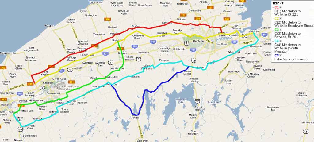
Section C Middleton to Wolfville
There are now at least 4 route choices: 2 very flat, 1 slightly hilly
and the last quite hilly. In general the more hills, the more scenic the
ride is.
Map of route for this section Annapolis Valley east
Download the GPX file for map
View
GPS Visualizer map
C(1) North route i Route 221 - moderately hilly
Start in Melvern Square, head north towards the North Mtn. There is a
bit of a steep hill and an illusion called a "Magnetic Hill" where it
looks like you are going down but you obviously are climbing. I don't
think motorists would notice this. Just before the hill gets really
steep you turn off.
- 2 km Right on Rt 221. The road climbs up a spur of the North Mtn. to
about 100 m. This will be the biggest climb on this route. There is a
nice view of the Valley. After crossing the Kings County Line a road
leads off to Kingston. There are rolling hills .
- 12 km Weltons Corner Jog left, then right crossing the Auburn-Morden
road. Another 4 km and you cross the Aylesford-Victoria Hbr. road.
The road passes past many apple orchards. Blossoms are in bloom at end
of May. apples are ripe in Sept. or Oct. From the small hills there
are more beautiful views. Next cross roads are Long Point Rd and
Berwick-Harbourville road. The road now flattens out.
- 32 km: Kinsman Corner ( Woodville).
Although Rt 221 goes straight here the Bligh Rd to left
makes a nice loop through orchards returning at Lakeville. This adds
about 2km . You can also turn off left on Thorpe Rd and pass by
vineyards along the base of the North Mtn. The infamous Chipman Brook
road ( very steep and rough) leads off Thorpe Rd.
- 38km: Back on Rt 221 and about 1 km to Silver Lake, the only
swimming spot in the area. There is a small beach and picnic area but
no facilities .
UPDATE (spring 2017) The Lakeville convenience store has gone
out of business, there are now no food stores on Rt 221 until
Centreville. Also, the only other convenience in the area is in
Somerset on Brooklyn Street.
- 39 km: Right at lake on Lakewoods Road . This is the direct route
to Wolfville or Kentville. At this point there are many options of
routes. The Map Book ( pg 13) is very useful here. Rt 221 continues to
Centreville, Sheffield Mills, Canning and Kingsport, all very nice.
This would be the way to go if you were on your way to Blomidon
Provincial Park but right now we are going to Wolfville( to jump there,
see: Kingsport extension
- 46 km Turn right on Rt 359 , then turn left on Reid Rd. Kentville is
about 3 km south on Rt 359.
- 48 km Turn right on Rt 341, then left on Church St. This road follows
a small ridge looking down on the Canard River dikes and now we get our
first view of Blomidon. Church St. continues all the way to Starr's
Point but here we'll take a short route to Wolfville. Feel free to
explore these nice roads. The only roads that will have much traffic
are Rt 359 Kentville-Centreville and Rt 358 P.Williams-Canning.
- 51 km: Right on Tiny Parish. It climbs a small hill where you will get a
view of Wolfville.
- 52 km: Left on Belcher St and it's downhill to Port Williams past some
more U pick strawberry farms. Just across Rt 358 at the corner is the
LUNCH BOX CAFEE.
- 56 km: Right on Rt 358 and cross Corwallis River which at low tide will be
empty but will almost up to the road when high. The bridge and highway
are narrow and the traffic can be heavy.
UPDATE. In 2010 we
got bicycle lanes on both sides of this road! Beware of the "rumble strip"
dividing the main lane from the bicycle lane.
- 58 km: Left at Greenwich on Rt 1 to Wolfville. Traffic can be very heavy
for next 3 km. There is a west-bound "bicycle lane" from Wolfville
to Greenwich. Maybe, we'll soon have a bike lane on the other side
of the road too!
To right Rt 1 goes to New Minas (4km). Although the road does have a
paved shoulder, N.M. is probably the worst place to bike in the Valley.
Mallsville or Fast Food City are fitting names. I suppose it may offer
relief to the urbanite who is bored from cycling through quiet rural
areas.
Just before Wolfville there is a big Farm Produce store and icecream
stand.
- 61 Km: Wolfville has everything the cyclist or anyone else could want.
There's a bike shop , a Natural Food Store & bakery with great bagels,
cheap restaurants, expensive restaurants, and a superb natural setting
with a stunning view of Blomidon across the Bay. WARNING! You may want
to spend the rest of your life here.
C(2) North Route Brooklyn Street or Middle Road
Back in Melvern Square turn east on Pleasant St. This road has several
names but Brooklyn St is the most common. It is very flat and very
quiet. Farm tractors are the most common traffic. In places the surface
is oil sealed sand, a temporary cheap pavement that may be a bit rough
if old. The road is low and often lined with trees so there aren't many
views but it is more sheltered from the wind.
- 2 km Marshall Road to right leads to Kingston. There is a nice Farm
Produce store near where this road joins Rt 1 . There is also a bike
shop in town and Greenwood Mall is a few km beyond.
- 7 km Jog left and right . This is a flat boggy area but you soon get
deep into orchards . Every few km there will a cross road leading to Rt
221 and Rt 1. There are several U pick strawberry places around and
often there will be berries etc. for sale in front of farm houses.
Strawberries: late June- mid July, raspberries: July, blueberries:
Aug-Oct, apples: Sept-Oct.
NOTE May 2012 The pavement on Brooklyn Street from the
Clairmont Rd to the Auburn-Morden Road has been ripped up, a section of
about 3 km.
- 22 km Junction of Rt 360 at Somerset. Right to Berwick . There is a
store at this corner. 2 km along there is a slight jog to left , sign
should point to Grafton. Shaw Rd to right is a pretty alternate way to
Berwick or Waterville.
- 27 km Grafton , junction of Waterville Rd. (former corner store here is closed).
In several places along here the road goes through a tree tunnel, where
great maple, oaks and elms spread their branches right over the road.
- 35 km Cross road to Lakeville and Silver Lake. Go left if you
want to go for a swim. The traffic will now be a little heavier as we
approach the suburbs of Kentville. The land becomes very sandy with pine
woods as we skirt the Aldershot Army Base and a wetlands bird sanctuary.
Then we enter Kentville. About 1km west of the Rt 359 junction there is
a picnic area by the Meadowview Community Hall (old schoolhouse) with
covered shelter, toilets, and water.
- 45 km Cross Rt 359 at traffic lights on to Belcher St. The Kentville
business district is only a few blocks to the right. Belcher Street
climbs through a nice residential area. From the top of the hill you
can look down on the malls of New Minas. There is a stop light at the
road which leads right to N.M. Belcher Street soon descends to Port
Williams (52 km) and Wolfville (57 km) as described above.
This route only goes as far as Berwick. From there we have to move to
one of the other routes.
-
Start at Nictaux , just south of Middleton. About 1 km we cross the
Nictaux river where there is a small swimming hole.
- 6 km Rt 201 jogs left, then right crossing Torbrook road. However
traffic will get a bit heavier as we approach Greenwood. There is a way
to bypass this but some of us may want to visit the Greenwood Mall which
has grocery stores, fast food outlets and a bicycle shop nearby.
- 10 km Major Corner . Kingston is 2 km to left. There is a picnic area
about half way. Keep straight to Mall. There will be fast food outlets
on both sides.
- 11 km Turn right at traffic lights. Greenwood Air Base ( largest in
Canada) is straight. Main mall be then be on left. Just past Mall Rt
201 turns left. Go straight on RockNotch road if you want to go to
Harmony on the South Mtn Road ( see C(iv) ). There always seems to be
construction here and roads in the Mall area may change. We could have
avoided all this by taking Meadowvale Rd which only adds 2 km.
Back at junction of Torbrook Rd turn right, go about 1km , then left
on Meadowvale Road . The first road left ( 3km) will take you right
into downtown Greenwood which we are trying to avoid so take the second
(6km) or 3rd left (8 km).
- 16 km Rt 201 officially turns left to Auburn. Go straight on Hall Rd.
to Millville. Now were are back in quiet countryside.
- 21 Jog in road. This is a slightly complicated corner. One road goes
right up the South Mtn. to Nicholsville. Follow signs to Factorydale.
- 24 km Cross Morriston-Lake George Rd. The road to right climbs one of
the highest hills in mainland Nova Scotia to a nice beach on LAke
George and eventually to Mahone Bay.
- 28 km Windermere on Rt 360 . Here we have to decide whether go up to
the South Mtn Rd or into Berwick and on to Brooklyn St. or Rt 221. Hill
climbers turn right. Others turn left. We are into major apple orchard
country now.
- 31 km Cross Rt 1. This road has fairly heavy traffic and is not very
scenic for cycling. Downtown Berwick is about 1 km north. If New York
City hadn't stolen the trademark, Berwick would be called the Big Apple.
It bears no resemblance to NYC. The tourist bureau is shaped like an
apple. It's quite a nice town with motels, B&Bs. There is a campground
about 5 km away. Rt 360 north leads to Somerset on Brooklyn St and
Welsford on Rt 221.
Most scenic route to Plantation Campground and Brooklyn St.: On north
side of town go east on road to Waterville. After 2km turn left on Shaw
Rd. It goes into a nice grove of trees.
This road goes by several names but it runs along the slope of the
South Mtn., sometimes high, sometimes low. There is a lot of climbing but
some great views on the Valley.
-
Starting at Nictaux ( Rt 10 & 201) , add 2 km if starting from
downtown Middleton. Go south towards Bridgewater.
- 2 km Left at Nictaux Falls. Cross the Nictaux River. On the left is a
power plant. On the right is a dirt lane going to a dam where there is a
good swimming hole. There may be also a pipe with spring water on the
left side of road.
Now it's about a 120 m climb , then down to Torbrook which used to be
a major iron mine. Note Bloomington Rd is a big climb and a dead end.
- 8 km Turn left on paved road. Gravel road to right has bigger climb and
great view. It comes down at Tremont.
- 10 km Turn right on Messenger Rd. and enter Kings County.
- 14 km Turn right at Tremont. Greenwood is about 3 km north. Now there
is a Freally steep hill ( 10%)
- 15 km Turn left . This road levels off then plunges down. The road is
oil-sealed sand which gets rough when old. WARNING! This a steep
downhill to a road junction. Across the junction is a narrow and often
rough bridge.
- 18 km Rockville Notch. Several interesting spots along this small
river in a narrow gorge. To the left a gravel road goes down towards
Greenwood. Watch closely on the right and you will see a path going into
the gorge. It passes the old mill site. It looks like there was a
big dam here many years ago. In the river are several small pools carved
in the rock and little waterfalls. Although small for serious swimming,
they could provide a refreshing dip.
Back across the bridge, the road climbs steeply again for half km.
Then on the right there is a dirt road to Crystal Falls. The first km
is rideable. Then it's best to walk. However I met a couple on MTN
bikes, carrying a baby in carrier, who went right to falls. Just before
crossing an old bridge take rocky path to left. Keep close to stream
and come to falls. There is a big pool below the falls . The water is
often very cold.
The road continues to climb to about 150m and becomes better pavement.
Below we can see the airbase runways and maybe even see a plane flying
below us! The road is fairly level along through Harmony and
Nicholsville. Orchards spread down the slopes.
Just before Morristown there is steep dip , with a dam on the right
with swimming possibilities.
- 29 km Aylesford-Lake George Rd. Turn right , climb a rather steep
hill.
- 30 km Turn left towards Rockland. Straight ahead to Lake George. That is
such an interesting diversion that I will insert it now.
C(5) OPTIONAL LAKE GEORGE DIVERSION. SERIOUS CLIMBING!
It's 10 km to Lake George up one of the highest paved roads in
mainland Nova Scotia. It may tie with Mt. Rose on North Mtn. at about
260 m . The corner is about 120 m we're already halfway up and the rest
isn't extremely steep. This road also continues all the way to Mahone
Bay on the South Shore. The road to the beach is on the left. It is
now (May 2012) paved. The Provincal Park beach is quite popular
and can be crowded on weekends. There is another public beach/picnic
area on Aylesford Lake, about 3 km past Lake George. The road continues
past cottage communities on Aylesford Lake to Caseys Corner ( South
Alton) where we join the main route again on Rt 12. The total diversion
is about 30 km ( 8 km extra).
RETURN TO MAIN ROUTE at
Morristown
- The Prospect Road continues with great views through orchards.
- 33 km Paved Road goes left down to Berwick. Go straight on good gravel
road to Rockland and Prospect. There is about 10 km of gravel (1993) but
the gravel section gets shorter every year. There are several paved and
gravel roads on left going down into the valley.
- 41 km Keep right to Prospect. Don't go left on paved road to Waterville.
At Prospect the pavement resumes and starts climbing more steeply.
- 49 km Right on English Mt Road to Caseys Corner. To the left it's
a fast downhill to Coldbrook. Our road has a steep dip then the top is
about 230 m with a great view near Caseys Corner. The Lake George
Diversion joins here.
- 52 km (Caseys Corner) Cross Rt 12 to Canaan Rd. The convenience
store at the corner is now closed (2015). The Canaan Rd. has a
few ups and downs .
- 57 km Turn right then left. The sign should point to White Rock.
There is a big dip and rise but the real fun hasn't started yet. Then
you get a view down the Gaspereau Valley and start down a great hill for
over 3 km. The only problem is there is a STOP sign at the bottom,
there are flashing warning lights.
- 64 km White Rock corner. There are now 3 roads to Wolfville. The
least hilly is to the left (Deep Hollow) which follows a winding gorge
cutting through the hill to Greenwich on Rt 1. Then it's about 5 km on
a rather busy road to Wolfville.
Just past White Rock corner, the Ridge Road goes to left.(1999 the
sign has been down for several years, but its the paved road just after
the lumber mill, opposite the White Rock church.) This climbs to the
top of Wolfville Ridge ( 150 m) There are fabulous views along the
ridge. There are 3 roads down into Wolfville: Highland Ave., Gaspereau
Ave., and Maple St.
Straight from White Rock goes into the beautiful Gaspereau Valley, the
"valley within the Valley". It is home of apple orchards, Gaspereau fish
(a large herring), "river tubing" and bald eagles. There are some good
swimming spots in the the pond and canal above the power station. At
Benjamin Bridge there are 2 choices as follows.
- 67km Straight on north and high side of river to Gaspereau village.
This is a gradual downhill and has a nice view .
- 67 km Right down very steep hill across canal then turn left on south
side or low side. Good swimming at bridge or you can ride up the canal
path to White Rock Pond.
The low road goes along the Gaspereau River below the power dam.
There is a lot of water in the river because it is fed by a series of
lakes and power dams on the South Mtn. On a summer day there will
probably lots of people floating down the river on tubes. Also at
milking time you may see herds of cows on road.
In the village, near the convenience store is a big pipe with
excellent spring water.
A new winery, Gaspereau Vinyards, has opened here. There
are a lot of vinyards on the north slope of the Gsapereau Valley now.
- 69 km Turn Right in Gaspereau village. At next corner left goes
across the "tubing" bridge , over the ridge into town, about 3 km, Right
continues down along the river to Melanson, Wallbrook and Avonport. The
easiest crossing of the ridge is at Melanson which leads into town on
Maple St. Also, from Wallbrook a road crosses over river and ridge to
Grand Pre. The lower Gaspereau Valley is a popular wintering grounds
for bald eagles. You may see some lingering in the spring. If you
haven't had enough climbing try Gaspereau Mtn. on the Greenfield Rd.
It climbs about 200 m in 2 km. There are several bike races up it.
- 72 km Wolfville. Closest campground is at Evangeline Beach near Grand
Pre.
We left our virtual cycle tourists in Wolfville. Let us return briefly
to Lakeville on tour section C(1) for an optional route.
Map of route for this section
extra loop to Kingsport
Download the GPX file for map
View
GPS Visualizer map
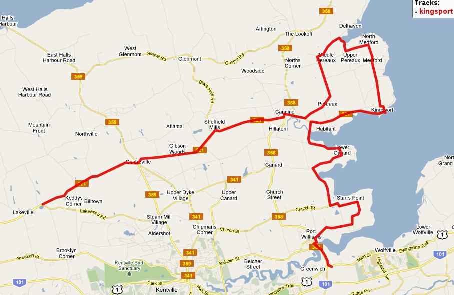
C(6)-extra Rest of 221 Lakeville-Kingsport-Wolfville
This extension takes us to to nice towns of Canning and Kingsport. It
is also the route to Blomidon Provincial Park. See the
Guide to North Mountain
for that and other hilly side trips.
- 39 km At Lakeville stay straight on Rt 221. You could also go on the
Thorpe road at the base of the North Mtn through some vineyards. For that
go back 500 m to the last store, turn right go about 2 km then right.
- 45 km Jog left and right crossing Rt 359 in Centreville. There is a
store at corner. An option is to go 1 km north on 359 and turn right on
Bains Rd which goes along base of North Mtn. to Sheffield Mills and
Canning via Atlanta. The first 3km is gravel. This is more hilly than
Rt 221.
If you are planning to visit the The Lookoff, the best route is
probably on the Glenmont Rd. from Sheffield Mills. Near Sheffield
Mills there are U-pick blueberry farms in Aug- Oct. Sheffield
Mills also claims to be the winter eagle capital of North America.
There probably won't be any eagles here between April and December.
- 54 km Canning is a very pretty town. There is a nice tea and desert
house here as well as some B&Bs. Keep going down the main street for
about 1 km.
- 55 Turn left on road to Pereaux and Blomidon.
- 61 At Upper Pereaux ( corner of Jackson Barkhouse) it is 8 km to
Blomidon Provincial Park. The last km to the camping area is very steep.
Return the same way or via Stewart Mtn. Rd. to Scots Bay Rd. and
Lookoff. ( see Guide to North Mtn)
To go directly to Kingsport turn right (left if coming back from BPP)
on Jackson Barkhouse Rd. It is good gravel for less than 1 km . You
may also be able to ride on top of the dike on left of road, this is
nice at high tide since you can see that the road is below sea level.
- 62 km Left on pavement to North Medford. This road is gently rolling and
there are some nice views of Blomidon.
- 67 Kingsport. Just to the left is the old wharf and beach. This used
to be major port where agricultural products were shipped out on big
sailing ships. This is one of the few places on the Bay of Fundy where
the water is warm enough in August for comfortable swimming. Of course
you have to be here at high tide. Several places along the Minas Basin
claim to have the world's highest tides.
About 2 km from Kingsport there is the Cabot Winery where you can
taste samples before buying a bootle of local wine.
- 71 km Left on Canning Aboiteau just at outskirts of Canning. An aboiteau
is a dike with a gate that lets water flow out but not in.
- 72 km Left on Saxon Rd to Lower Canard. The road goes along the shore and
loops around Porter Pt.
- 76 km Left on Wellington Dike. The road dips through orchards down to the
dike.
- 79 km Left on Church St. For a shortcut to Port Williams, turn right
here, go 1 km then turn left on next paved road.
- 80 km Left to Starr's Pt. Straight is another shortcut.
- 81 km Prescott House is a Provincial Museum with nice gardens. There are
also U pick strawberry and apple farms here.
- 85 km Left on Rt 358 in Port Williams and we are back on original tour.
- 90 km Wolfville.
The Wolfville area has many nice cycling possibilities. The
Wolfville Ridge Rd., the Gaspereau Valley , a trip to Lumsden Dam or the
3 pools are all only as short distance away. One interesting ride is on
the dikes, especially at high tide. The tops of the dikes may be a
little rough in places but there is a smoother road along the base.
East of Wolfville Rt 1 becomes more suitable for cycling and even has
some scenic views. There are several alternate ways to Windsor where the
Valley officially ends. All these routes are hilly.
D(1) Wolfville-Hantsport via Gaspereau Mtn. (very hilly)
Head up Gaspereau Ave. You could also go up Highland Ave or Maple St.
and join up via Ridge Road which has a nice view. It's about a 100m
climb to the top of the ridge but that's just a warm up for the real
hill. Then it's back down to Gaspereau.
- 3 Km Turn right just past the bridge (the "tubing bridge"). There is a
second right which goes to Lumsden Dam which will be explained later.
The hill now starts and climbs about 200 m in about 2 km. You get a
nice view to the right while climbing and quite a sight at the top. The
Road levels off then gradually descends towards Greenfield.
- 7 km Davison St comes in from right. Here the Lumsden option joins
again.
Lumsden Option : From Gaspereau ride along river. You may see some
river tubers going downstream. After 2 km of flat road you start up a steep
hill which climbs 120 m in 2 km.
- **10km Lumsden Dam to right. The picnic area and beach are just across the
dam.
- **13km Left on Davison St and up another steep hill, another 100 m climb.
Then it's quite a steep downhill to the main route at 17km ( 10 km
longer)
- 10 km Greenfield where pavement ends. Pass Peck Meadow Rd. Turn left
on second road, it should be marked Bishopsville. There is a small
waterfall on right with a pool below where you could take a quick dip.
Now we gradually descend on a shady, winding road beside a babbling brook.
The road is usually in good condition except in early spring.
- 17 km Bishopsville where pavement resumes. We are now in a flat
valley. The road then climbs a bit going towards Hantsport. It goes
through a culvert under Rt 101 at the outskirts of Hantsport. Just
before the culvert a gravel road (Old Post Road) to right is a shortcut
to Bog Rd. which goes to Windsor.
- 25 km Right on Rand St in Hantsport. If you wanted to loop back to
Wolfville, turn left.
- 25.5 km Left on Bog Rd to downtown, right to Windsor. It is fairly steep
down into town. Bog Road changes its name to Holmes Hill Rd.
- 26 Junction Rt 1. There is a picnic area and museum near this corner.
Hantsport stores are a little farther. To Windsor take Rt 1 or Bog Rd.
Rough map of routes through Hantsport
Map of route for this section Wolfville to Windsor
Download the GPX file for map
View
GPS Visualizer atlas map
D(2) Wolfville to Windsor on Rt 1
East of Wolfville traffic on Rt 1 is moderate but I still prefer the
Gaspereau Valley for the first bit which only adds one hill.
The easiest way over the ridge is via Maple St. Gaspereau Ave or
Highland Ave via Ridge Rd are also possible. Starting at corner of Main
and Gaspereau go east on Rt 1 and pass the tourist bureau and park.
- 1 km Right on Maple St. There is a farm produce market around the
corner, especially good in apple season. The climb is only 60 m and
there is a view of the Gaspereau valley coming down.
- 5 km Left at Melanson and then follow the Gaspereau River. There are
small produce stands selling in season: berries, corn, tomatoes, apples
and pumpkins. You can almost touch apples or trees while riding past
the orchards here.
- 8 km Right goes up West Brooklyn Mtn which probably has the best view
of Cape Blomidon. It is a 150 m climb and you loose 50 m getting back
to the main route. If you don't want the extra climb keep straight to
Avonport.
- 11 km Another choice. Either keep straight on right side of freeway
(Rt 101) to West Brooklyn, climb for about 1 km, then cross over
freeway to Rt 1.
Or Left, cross freeway , then right on Rt 1. The former is
slightly shorter but steeper. Either way we climb about 120 m, there
will be a nice view behind. Then it's a nice 4 km run down to Hantsport.
For more climbing you can take the Lockhartville Rd to the left.
- 19 km Left for first exit to downtown Hantsport. Rt 1 continues
straight still going downhill. In downtown Hantsport there is the CHAPTER 2
CAFEE, severing light lunches and deserts.
- 20 km Junction of Main St ( left) and Bog Rd (right) Rt 1 has several
short but steep hills through Mt Denson to Falmouth. There are 2 railway
crossings at bottoms of hills.
- 28 km Bog Rd comes in at outskirts of Falmouth. Dike Rd and Falmouth
Back Rd to right are nice side roads which go to Upper Falmouth where
you can connect to Rt 14 or you can make a loop back to Windsor.
- 31 km Cross Bridge into Windsor. There is a little park with beach on
Falmouth side.
D(3) Wolfville - Windsor via Bluff Rd and Bog Rd
This crosses Rt 1 in Hantsport so you can switch routes there. The
first 11 km to Avonport is the same as D(2).
- 11 km Cross the freeway and go straight on Bluff Rd. The first part is
flat but beware of 2 tricky railway crossings. Then there are 3 or 4
short hills. Rt 1 only has one long hill so the total climb is about
the same. The road goes into the Hantsport main street. The prettiest
section of town is on Avon St. to the left, a tree lined street with
nice gardens.
- 21 km Cross Rt 1 on to Bog Rd (Holmes Hill Rd) which climbs out of
town, crosses over Rt 101 and then descends again. The rest of the road
is very flat with very light traffic. The area is boggy and, at first
glance, dull , but red-winged blackbirds are in abundance and there may
be waterfowl in the marshes. There is an old plaque on a rock marking
the spot of a stage coach accident in 1850's that killed some Hantsport
resident.
- 29 km Join Rt 1 again in Falmouth
- 32 km Windsor as above
In Windsor An interesting museum for cyclists is the Shand House.
Clifford Shand was a prominent cyclist in the 1890's
A hilly century suggestion (Forties).
If you are in the Wolfville-Windsor area and want a challenging century
this loop is about 160 km with 1500 m of climbing. I'll start from
Windsor/Falmouth.
Falmouth-Falmouth Dyke Rd, Sangster Bridge to Rt 14 ( Chester Rd).
At Vaughn right on New Ross Rd. At New Ross take Forties Rd to Dalhousie Rd,
then Right on Aylesford Rd to Lake George.
Then right past Aylesford Lake to South Alton. Then Canaan Rd
to White Rock, Gaspereau Valley to Avonport. Then Rt 1 and Bog Rd to
Hantsport and Windsor.
There's lots of hills but mostly quiet roads. There are at
least 3 swim stops at Vaughn, Lake George and Gaspereau .
Map of route : Forties Century
Download the GPX file for map and elevation profile
View
GPS Visualizer atlas map
Tourist Info
The best source of general info is:
    Nova Scotia Dept of Tourism and Culture
    Box 130, Halifax NS, B3J 2M7
    1-800-565-0000 Canada
    1-800-492-0643 Maine
    1-800-341-6096 rest of USA
Their Nova Scotia Travel Guide contains lots of info on campgrounds,
motels,points of interest etc. They also supply free highway map.
Topo Maps($8 each) and the Map Book of Nova Scotia (ISBN0-88871-074-7)
(about $15 )can be ordered from:
Nova Scotia Book Store
Box 637, Halifax NS B3J 2T3
Nova Scotia Bicycle Touring Index
HOME
David Dermott
(david@dermott.ca)
Wolfville Ridge , Nova Scotia, Canada